Okanogan
and Ferry County Chapter
Washington
Pilots Association
ADS-B
Don
Fitzpatrick recently took the
leap and had ADS-B installed in
his Maule. For non-pilots, ADS-B
stands for Automatic Dependent
Surveillance - Broadcast. This
equipment lets you be seen by
other aircraft and lets you see
other aircraft on your GPS
screen (or other glass cockpit
screen). It is required of all
aircraft who want to fly into
Class B airspace (like Seattle)
after 2019. 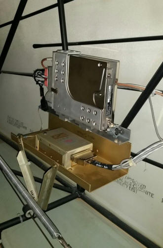
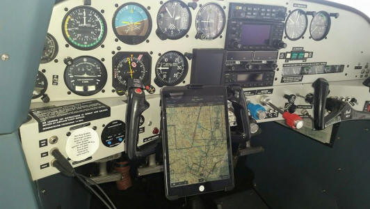
The first picture shows the
equipment installed in the tail
of the airplane. The equipment
with installation cost varies
depending upon the type of
equipment you already have. In
this case it was about $8,000!
This did include the Flight
Stream equipment which sends the
information to your iPad via
Bluetooth, along with weather,
airport data (including fuel
prices), and other information.
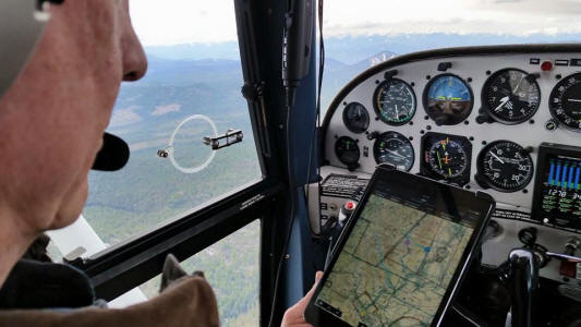
The second picture shows the
iPad with the local chart in
use, mounted on the yolk and
working with the ADS-B. The
other photos show the pilot is
synced to the iPad, and the iPad
is synced to the GPS.
Don elected to go with Garmin
Pilot when he found out that
Garmin Pilot worked best with
his Garmin Gear than other
options.
The Garmin GDL 88, which does
everything but 1090 ES Out (this
would come with the ES
Transponder which he doesn’t
have) and Active traffic
surveillance. The Garmin GDL 88
gives the ADS-B out and in; plus
it includes the FIS-B weather,
TIS-B traffic, and air to air
data on both 1090 ES and 978 UAT
links. It also gives spoken
audio alerts, such as "Traffic -
Seven o'clock - Your altitude -
Less than a mile". The
information goes to his 430 GPS
by direct wire link from the GDL
88.
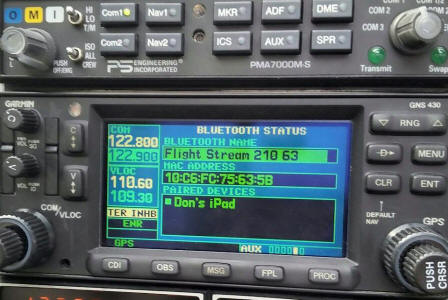
The Garman Flight Stream came
in two models: Flight Stream 110
and Flight Stream 210. He got
the 210 model for $1,000. It is
connected to the GDL 88. The
Flight Stream is what connects
the Garmin GDL 88 info via
Bluetooth to the iPad. He turns
on the iPad Bluetooth, finds and
syncs to the Flight Stream, and
then get all the data on his
iPad that he’d get on the 430
GPS, only with a much bigger
screen and easy access to
overlays such as cloud cover,
winds, etc.
With Garman Pilot, he can do
flight planning at home, build a
flight plan, file it, get the
weather information from DUAT
(DTS or CSC), and activate the
flight plan, etc. (You still
open the flight plan by radio.)
Either Garmin Pilot can't do
weight and balance like Fore
Flight or he hasn't figured out
how yet. When he gets into the
airplane and is synced, he can
transfer the flight plan to the
430 GPS from the iPad via the
Flight Stream.
On the iPad the air traffic
shows up as an airplane symbol
pointing the direction of travel
and a + or – altitude, so you
know if the traffic is below or
above you and how many feet.
Because it reads air to air data
on frequency 1090 (transponder
frequency) you get that data, in
addition to ADS-B data, so you
see aircraft that only have
transponders as well as those
with ADS-B.
Don felt the ability to "see"
other aircraft made it well
worth the expense. He is still
learning all the details of
operating the iPad to take
advantage of all the information
available...but he's catching on
quickly.
Washington State
PILOT’S PARADISE
Okanogan County
Do you like
to fly for fun? Are you
looking for a new adventure?
Here is a trip that will thrill
you, your passengers, and be
remembered for a lifetime.
This can be done in one day, or
you can spend a very pleasurable
long weekend. From
anywhere in Washington we are
talking about less than 4.5
hours of air time. It all
depends on where you start, of
course.
Consider an
air tour of Okanogan County.
It is the largest county in
Washington and bigger than the
state of Connecticut!
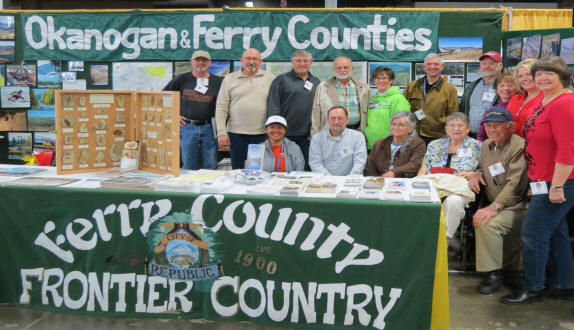
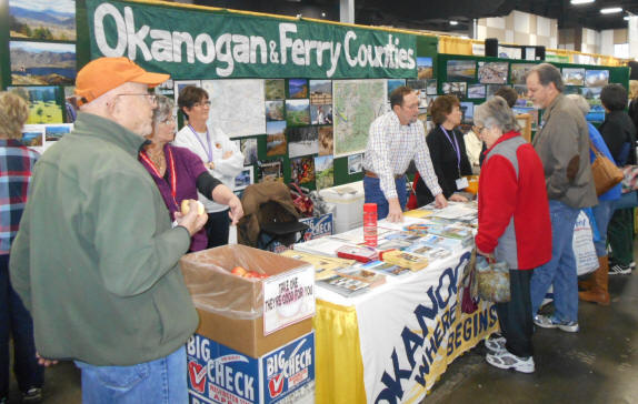
When the Washington Pilots
Association go to the Washington
Aviation Conference at Puyallup
every year we have a booth
displaying Okanogan and Ferry
County flying and recreational
opportunities, plus we give out
apples grown in our area.
People are amazed! They
don’t know where Okanogan County
is. They don’t realize we
have seven paved airstrips, huge
recreational opportunities, and
some unique opportunities for
pilots. Let me suggest a
great trip…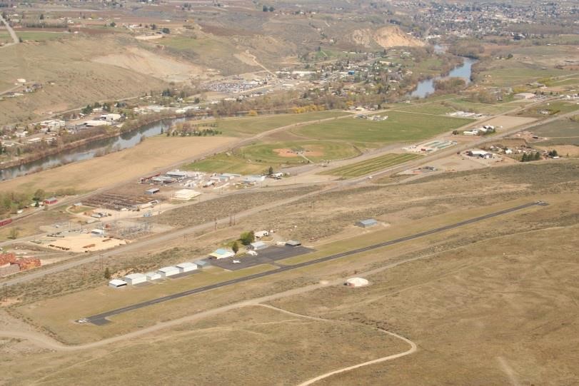
Start by
planning your flight from
wherever you base to Wenatchee
(EAT). When you get here,
promise to ignore your GPS and
use only the sectional and my
suggestions. Slow down and enjoy
flying like it used to be.
Follow the Columbia River north.
You will pass Chelan (S10) on
the North side. This is a
wonderful strip with gas. About
2 miles further, note the
beautiful private strip on the
right side of the river (River
View – Private). Continue
following the river until you
get to Anderson Field in
Brewster (S97). This is where
the Okanogan River flows into
the Columbia. Brewster is the
first of seven paved airports
located in Okanogan County.
If you have the time, consider
landing at each of them.
Not many pilots have done this.
If not, just turn left (north)
and follow the Okanogan River.
You are in for a real delight.
Flying up the Okanogan you will
see fields, orchards, lakes,
foothills, mountains, and
delightful natural beauty.
Emergency landing opportunities
are plentiful. There are
many private ranch strips along
the way, too. See how many
you can count.
You will
pass Monse. Check out all
the radar dishes on the left!
I don’t know what they do, but
they sure look impressive. Then
you will see Malott, and shortly
thereafter, the Okanogan Legion
Airport (S35). If you stop
here you will find a very nice
courtesy car and you can visit
Okanogan and Omak, which are
side by side communities.
Okanogan is the county seat for
Okanogan County. A good place to
eat in Omak is the Bread Line
Café. This is a bakery and
restaurant that will delight
your palate.
Omak, which
is adjacent to Okanogan, has a
beautiful airport, with fuel.
Unfortunately it has no rental
cars and is not really close to
town. Omak is the home of
the Omak Stampede and the famous
Suicide Race.
Continue
north, following the river,
passing towns like Riverside,
Keystone, and Tonasket.
Give some thought to landing at
Tonasket. It is a
wonderful airport and has an
airport car, which is an old
police vehicle. It looks
pretty rough, but no one will
pull you over. Interesting
antique stores and restaurants
are in this town, which is
filled with friendly people.
By the way, this is the seat of
the Washington Pilot’s
Association for the Okanogan and
Ferry County chapter. A
good fly-in is held at the
Tonasket Airport (W01) on
Father’s Day weekend every year.
It is a lot of fun with a great
barbecue on Saturday night and
pancake breakfast on Sunday.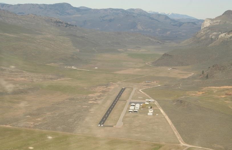
Follow the
river about 15 miles further
north and you will arrive at
Oroville (0S7). This is
one of the fastest growing areas
in Okanogan County. The
wine producing interest from
Canada is spreading south.
The River you have been
following slows down to a
meander as it comes into its
source, Osoyoos Lake.
Bring your passport if you want;
land here and rent a car to
visit over 100 vineyards and
wine shops in this beautiful
area on both sides of the lake.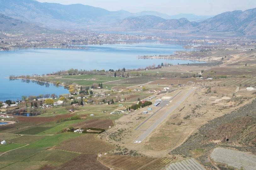
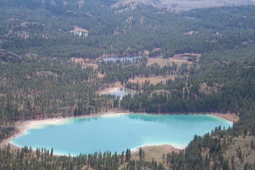
Now, turn
180 degrees and head back
downriver, but go a little west
of Omak. Climb to about
4,000 feet. You will go
over the foothills NW of Omak
and see numerous beautiful
hidden lakes that are the color
you would expect at a south sea
island. Check out the green
valleys that beckon you to
follow them to the west.
When you
get back to Omak, head west to
S52 (Winthrop Smoke Jumper’s
Base at the Methow Valley State
Airport). You will now
need to climb to about 6,500 to
get over the hills, but you will
see lots of lakes, mountains,
ranches, and you might even see
the Loup Loup Ski Area. If
you are planning this trip as a
weekend trip, as you descend
into the Methow (silent ‘h’)
River Valley you will have to
make a decision on where to stop
and stay.
The
Winthrop Smoke Jumper Base (S52)
is a 5,000 foot State airport,
which has self-service fuel,
provided by a local dentist.
He is maintaining three
airplanes, one jet, and two
helicopters. He obviously
needs your help. But, his
fuel prices are reasonable.
Parking is free on the west side
of the field, as it is
everywhere in the County, but
there is no courtesy car here.
However, almost every lodging
establishment in town will pick
you up at the airport if you
register and/or call in advance.
Once you get to lodging you can
walk to almost anything you want
to do. You might want to
call Dan and Sally Kuperberg,
(996-3107) who own the Chewuch
Inn. He is one of our WPA
members and easy to know and
like. If they are full, call
Rich and Dolly Stahl at the
Methow River Lodge and Cabins
(996-4348). The Smoke
Jumpers will often provide a
tour of their facilities, if
they aren’t too busy fighting
fires.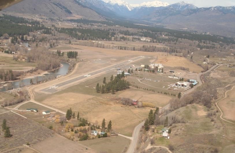
At Twisp
Airport (2S0) 2700 feet, home of
the majority of the general
aviation aircraft in the area,
you can use a courtesy car.
Here again, most accommodations
will pick you up if you call in
advance. Try Sandy and
Bill Moody (997-5970), who
operate a bed and breakfast.
Bill has worked with the Smoke
Jumpers for more years than I
have been flying and has
wonderful tales to tell.
From their place you can go to
many venues in Twisp that will
remind you of your time growing
up. Visit the Twisp River
Pub. If possible, attend a
play at the Merc Playhouse. Go
to the Saturday morning market.
Interesting things are
happening every weekend at Twisp
and Winthrop.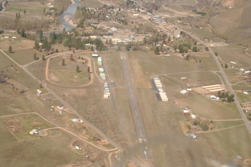
All that is
left is a short trip down the
Methow River valley to Pateros
where you turn right down the
Columbia and return home. In my
Maule this round trip (not
including the flight from
Wenatchee and back) took about
1.5 hours. I hope you
enjoy it.
Don
Fitzpatrick, Jr.
Don is a
private pilot currently flying a
tricycle Maule. He lives
in the Mazama area and has
landed his Maule at every public
airport in Washington State.
He is a WPA, AOPA, and EAA
member.
This
article was printed in WINGS –
June-July 2014 and General
Aviation News – January 5, 2015
Page Last Updated: 05.21.17